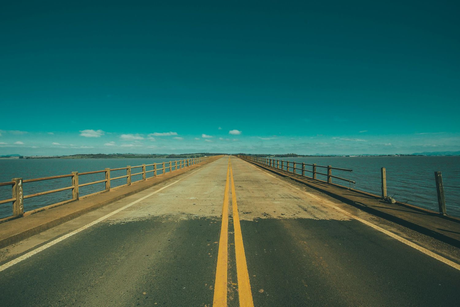
The drive to Key West along the Overseas Highway is one of America’s iconic road trips. The 113-mile route from Florida City (Mile Marker 127) to Key West (Mile Marker 0) crosses 42 bridges — including the legendary Seven Mile Bridge — and threads through 800+ small islands of the Florida Keys, with the Atlantic on one side and the Gulf of Mexico on the other for most of the journey. Done well, the drive takes a full day with stops; done as a transit, it’s 3.5-4 hours from Miami International Airport. This guide covers everything road trippers need: detailed mile-by-mile stops (Key Largo’s John Pennekamp Coral Reef State Park, Islamorada’s Robbie’s Marina tarpon feeding, Marathon’s Turtle Hospital, Bahia Honda State Park’s white-sand beach, the historic Seven Mile Bridge, the Sugarloaf Bat Tower), where to gas up, where to eat (Mrs. Mac’s Kitchen, Hungry Tarpon, Keys Fisheries, No Name Pub, Mangrove Mama’s), where to spend the night if you split the trip, and the alternative routes (Card Sound Road bypass), with current pricing and seasonal advice. Written by Key West locals who have driven this route hundreds of times.
You will get exact mile markers for each major stop, the difference between bayside (west) and oceanside (east) navigation, the gas stations between Marathon and Key West (limited — top off in Marathon), the cell-service dead zones (most of MM 30-15), the EV charging stations (limited, Key Largo and Marathon mainly), the bicycle Overseas Heritage Trail (yes — it parallels much of the road), and a sample 1-day, 2-day, and 3-day driving itinerary.
Key Takeaways
- Distance: Florida City (MM 127) to Key West (MM 0) = 113 miles.
- Drive time: 3.5-4 hours direct; 6-8 hours with stops; 2-3 days for proper road trip.
- From Miami International Airport: 165 miles, 4 hours.
- Bridges: 42 total. Seven Mile Bridge (MM 47) is the icon — actually 6.79 miles long.
- Best stops: John Pennekamp (Key Largo, MM 102), Robbie’s Marina tarpon feeding (Islamorada, MM 77.5), Bahia Honda State Park (MM 36), National Key Deer Refuge (Big Pine, MM 30).
- Gas: Top off in Florida City and Marathon (MM 50). Limited gas south of Marathon.
- No tolls on the main Overseas Highway (Card Sound Road bypass has $1 toll).
- Cell service: Most providers have dead zones MM 30-15.
Why Drive to Key West?
Three reasons. First, the route is its own attraction. The Overseas Highway runs through 800+ small islands, crosses 42 bridges, and offers ocean views for most of its length — a road trip experience that rivals Pacific Coast Highway or Going-to-the-Sun Road. Second, the cost. Driving from Miami is roughly $50 in gas (round trip for one car) versus $300-600 in flights for a couple. Third, the freedom. With your own car you can stop at Bahia Honda for a swim, eat at Robbie’s, take photos at Seven Mile Bridge, and pull over wherever a bridge view catches your eye.
The trade-off is time. The 113-mile drive is 3.5-4 hours direct (Miami to Key West) or 6-8 hours with reasonable stops. Add 1.5 hours from Miami International Airport. If your trip is short (3 days or less), flying directly to Key West International Airport (EYW) saves the day each direction. If your trip is 5+ days, the drive becomes worth it.
The Route: Mile Marker by Mile Marker
Mile markers count down from 127 in Florida City to 0 in Key West. They are clearly posted along the highway, mostly on the bayside (west) edge. Bayside refers to the Gulf of Mexico side; oceanside refers to the Atlantic side. Locals give directions as “MM 102 oceanside” or “MM 81 bayside.”
MM 127-106: Florida City to Key Largo
The drive begins in Florida City, the last mainland town before crossing into the keys. Top off gas, grab snacks. The road becomes the Overseas Highway as you cross the first bridge over Jewfish Creek into the keys.
MM 106: Welcome to Key Largo, the largest of the Florida Keys islands and the diving capital of the world.
MM 102-100: Key Largo Highlights
John Pennekamp Coral Reef State Park (MM 102.5, oceanside) — first underwater state park in the United States. Glass-bottom boat tours, snorkeling, scuba, kayaking. The famous Christ of the Abyss bronze statue sits in 25 feet of water at Dry Rocks reef. $8/vehicle entry.
Mrs. Mac’s Kitchen (MM 99.4, bayside) — the iconic Key Largo lunch stop. Fish tacos, conch fritters, key lime pie. Open since 1976.
Florida Keys Brewing Co. (MM 100.2, bayside) — local craft brewery with tasting room.
MM 90-71: Islamorada
The “sportfishing capital of the world.” Several major stops in this stretch.
Robbie’s Marina (MM 77.5, bayside) — the famous tarpon feeding. $2.25 dock fee + $4 bucket of bait. Hand-feed 100+ pound tarpon (giant silver fish). Pelicans steal bait. Most-photographed Islamorada stop. Don’t miss.
Theater of the Sea (MM 84.5, oceanside) — older marine park, dolphin/sea lion encounters.
History of Diving Museum (MM 83, bayside) — small but excellent maritime/diving history museum.
Hurricane Monument (MM 81.5, oceanside) — memorial to victims of the 1935 Labor Day Hurricane that killed 400+ World War I veterans building the original Overseas Highway.
Hungry Tarpon (MM 77.5 at Robbie’s) — diner-style food, great breakfast.
Cheeca Lodge & Spa (MM 82, oceanside) — historic resort, popular overnight stop.
MM 60-47: Marathon
Marathon is the second-largest community in the keys after Key West. Last gas before Key West (top off here).
Turtle Hospital (MM 48.5, bayside) — the only sea turtle rehabilitation hospital in the country. Guided tours of recovering turtles. $30 adults, $15 kids. Highly recommended for kids.
Dolphin Research Center (MM 59, bayside) — interactive dolphin programs. $30 entry.
Sombrero Beach (MM 50, oceanside) — large public beach, free, family-friendly.
Pigeon Key (MM 47) — historic railroad worker village from Henry Flagler’s Overseas Railroad era. Accessible only by ferry from the Marathon side. Historical museum.
Keys Fisheries Market & Marina (MM 49, bayside) — large fresh seafood market and waterfront restaurant. The legendary lobster Reuben sandwich. Locals’ favorite.
Castaway Waterfront Restaurant (MM 47.8, bayside) — iconic Marathon seafood spot.
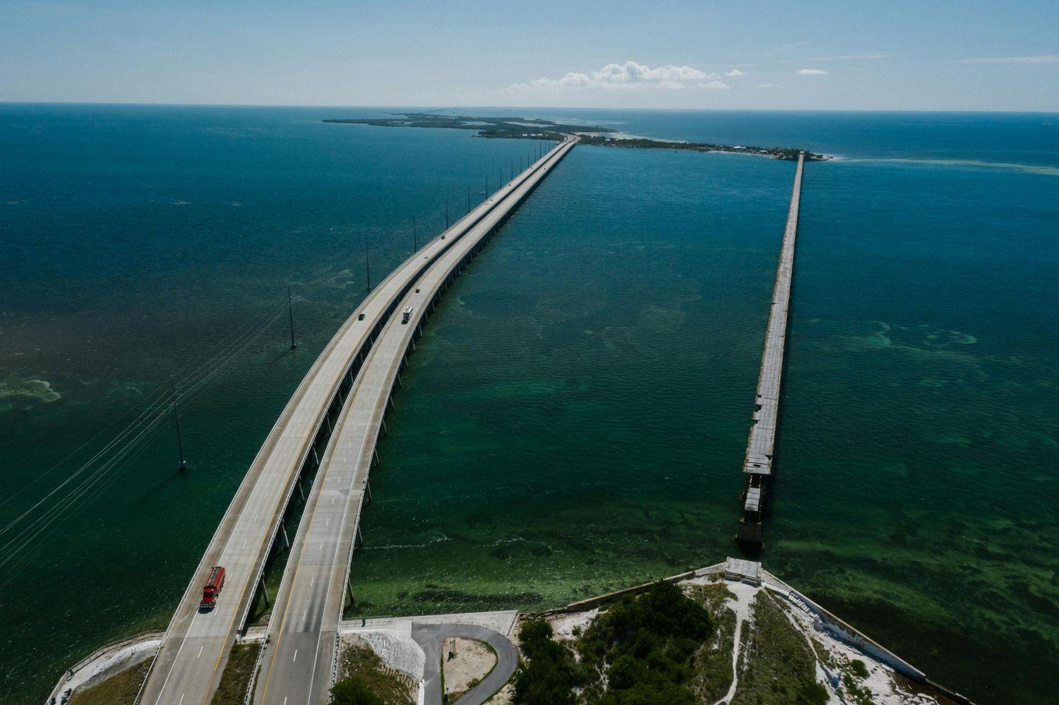
MM 47: Seven Mile Bridge
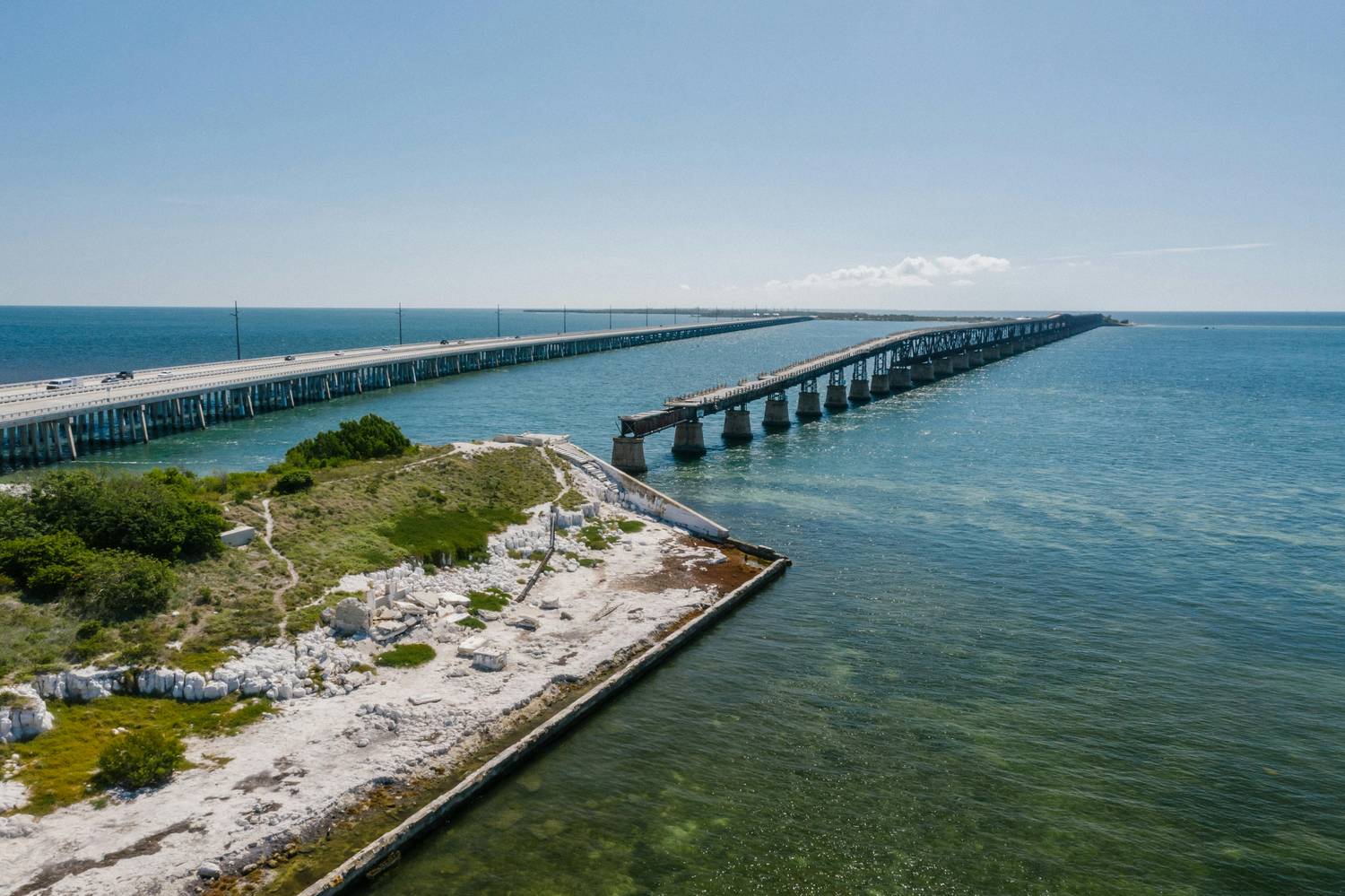
The most iconic bridge of the drive. Actually 6.79 miles long, connecting Knight’s Key in Marathon to Little Duck Key in the lower keys. Built 1979-1982 to replace Henry Flagler’s original 1912 railroad bridge (which still stands as a parallel walking/fishing pier on the south side). The current bridge has a small parking pull-off at the south end (MM 40 area) for photos.
Old Seven Mile Bridge: The original Flagler-era railroad bridge runs parallel to the south. Walkers and bicyclists can access portions for free as the Florida Keys Heritage Trail. Pigeon Key is reached via the Old Seven Mile Bridge.
MM 38-36: Bahia Honda State Park
The crown jewel of the lower keys. Bahia Honda State Park at MM 37 has been voted “best beach in the United States” multiple times. Wide white-sand beach (rare in the keys, which are mostly rocky coral coastline), calm shallow water, excellent snorkeling, the iconic remnant of Henry Flagler’s original railroad bridge as a backdrop. $9/vehicle entry. Picnic areas, snack bar, restrooms, kayak rentals. Plan 2-3 hours minimum here.
The Old Bahia Honda Bridge — the highest of the Flagler-era railroad bridges — sits adjacent and is one of the most photographed structures in the keys.
MM 33-30: Big Pine Key (Key Deer)
The National Key Deer Refuge protects roughly 700 endangered Key deer — a miniature subspecies of white-tailed deer found only in the lower keys. The deer stand about 24 inches tall and are often visible from the road on Big Pine Key, especially in early morning or late afternoon.
Blue Hole Observation Platform (off MM 30) — small freshwater pond with alligators, turtles, and Key deer sightings. Free.
No Name Pub (off MM 30, North Watson Boulevard) — legendary off-the-beaten-path pub with dollar-bill-covered walls and the local beer cult following. Worth the detour.
MM 17: Sugarloaf Key
Sugarloaf Bat Tower (MM 17) — small wooden tower built in 1929 by entrepreneur Richter Perky to attract bats for mosquito control. The bats refused to move in. The tower remains as a quirky historical curiosity. The original tower was destroyed by Hurricane Irma in 2017; a replica was rebuilt.
Mangrove Mama’s Restaurant (MM 20, bayside) — eccentric local restaurant with strong food, live music, and a tropical-jungle atmosphere.
MM 5: Stock Island
The last island before Key West. Working-class commercial area. Stock Island is where the shrimp boats unload and where Hogfish Bar & Grill (the most-recommended local seafood spot) is located.
MM 0: Key West
The Mile Marker 0 sign at the corner of Whitehead and Fleming Streets in Old Town marks the official end of US Highway 1. Free photo. Bring a smile.
Sample Itineraries
1-Day Drive (Direct Transit)
Miami International Airport pickup, drive direct to Key West with one lunch stop. Total time: 4.5-5 hours including a 30-minute lunch break. Best for: travelers with limited time.
Suggested lunch stop: Mrs. Mac’s Kitchen in Key Largo (MM 99.4) — convenient and good food.
1-Day Drive with Stops
Leave Miami early (8 a.m.). Drive to Key Largo. Coffee and quick walk at John Pennekamp (1 hour). Continue to Islamorada. Tarpon feeding at Robbie’s (1 hour). Lunch at Hungry Tarpon. Continue to Marathon. Turtle Hospital tour (1 hour). Top off gas. Continue to Bahia Honda — quick swim or pull-over photo (30 minutes). Arrive Key West by 5-6 p.m. for sunset.
2-Day Drive (Overnight in Marathon)
Day 1: Miami to Marathon. Stop at John Pennekamp, Robbie’s tarpon feeding, Cheeca Lodge for a quick walk. Lunch at Hungry Tarpon. Arrive Marathon by 4 p.m. Stay at Hawks Cay Resort (Duck Key, MM 61) or Isla Bella (Marathon). Sunset at Sombrero Beach. Dinner at Keys Fisheries.
Day 2: Morning Turtle Hospital. Top off gas. Drive to Bahia Honda for swim. Visit Big Pine Key Blue Hole (look for deer). Lunch at No Name Pub. Continue to Key West. Arrive by mid-afternoon for hotel check-in.
3-Day Drive (Two Overnights)
Same as 2-day but with an additional overnight at Cheeca Lodge or Bungalows Key Largo. Adds time for John Pennekamp diving/snorkeling and a leisurely Islamorada day.
Where to Eat Along the Way
Mrs. Mac’s Kitchen (MM 99.4, Key Largo) — fish tacos, conch fritters, key lime pie. Iconic.
Alabama Jack’s (Card Sound Road) — only accessible via the toll bridge alternative. Crab cakes, ramshackle dockside vibe.
Hungry Tarpon (MM 77.5, Robbie’s Marina) — diner food, great breakfast.
Keys Fisheries Market & Marina (MM 49, Marathon) — fresh seafood market plus waterfront restaurant. The lobster Reuben.
Castaway Waterfront Restaurant (MM 47.8, Marathon) — iconic Marathon seafood.
No Name Pub (off MM 30, Big Pine Key) — beer, pizza, dollar-bill walls.
Mangrove Mama’s (MM 20, Sugarloaf) — eclectic local restaurant.
Where to Stay Overnight
Bungalows Key Largo (MM 99) — adults-only all-inclusive bungalow resort. Premium pricing $700-1,500/night.
Cheeca Lodge & Spa (MM 82, Islamorada) — historic luxury resort, $400-1,000/night.
Hawks Cay Resort (Duck Key, MM 61) — large family resort. $400-900/night.
Isla Bella Beach Resort (MM 47, Marathon) — newer luxury, $400-1,000/night.
Hyatt Place Marathon (MM 50) — chain reliability, $200-450/night.
Tranquility Bay Beach House Resort (MM 49, Marathon) — beachfront cottages, $400-800/night.
Practical Driving Logistics
Gas Stations
Plenty of gas in Florida City, Key Largo, and Islamorada. Marathon has multiple stations — top off here. Limited gas south of Marathon (Big Pine Key has one station, Sugarloaf has one). Plan to fuel up at Marathon (MM 50) before the final stretch.
Cell Service
Most carriers have dead zones in the lower keys, particularly MM 30-15. Verizon and T-Mobile both have gaps. Download maps offline before driving the lower keys.
EV Charging
Limited but expanding. Tesla Superchargers in Florida City (north of MM 127), Key Largo, and Marathon. Other Level 3 charging at Hyatt Place Marathon and a few other locations. EV travelers should plan charging stops carefully.
Tolls
The main Overseas Highway is toll-free. The alternative Card Sound Road bypass (which avoids Key Largo traffic) charges $1.00 toll cash or SunPass.
Speed Limits
55 mph on most stretches. Drops to 35-45 mph through commercial areas in Key Largo, Islamorada, Marathon, and Big Pine Key. Speed enforcement is active, especially in Big Pine Key (Key deer protection).
Hurricane Evacuation
The Overseas Highway is the only road off the keys. Hurricane evacuation orders trigger heavy congestion. Plan around named-storm forecasts during hurricane season (June-November).
Card Sound Road Alternative
For the first 30 miles, an alternative route exists: Card Sound Road. Departing Florida City heading south on US-1, take Card Sound Road east. The route bypasses traffic-prone Key Largo via a $1 toll bridge. Adds 5-10 miles but typically saves 15-30 minutes during peak congestion. Notable stop: Alabama Jack’s restaurant on the Card Sound Road. Both routes converge in Key Largo.
Bicycle Alternative: Florida Keys Heritage Trail
The Florida Keys Overseas Heritage Trail is a 106-mile paved bike path that parallels much of the Overseas Highway. Long-distance cyclists can ride from Key Largo to Key West over 2-3 days. The trail crosses the Old Seven Mile Bridge (closed to cars) and the Old Bahia Honda Bridge for traffic-free bridge experience.
Alternatives to Driving
Greyhound bus from Miami to Key West: $35-55, 4-5 hours. Limited daily departures.
Key Shuttle private shuttle: $50-85 per person, door-to-door from Miami area.
Key West Express ferry from Fort Myers Beach: $145-195 round trip, 3.5 hours.
Direct flight to Key West International Airport (EYW): from Miami, Atlanta, Dallas, Charlotte, Newark seasonal. $150-450.
Best Time to Drive
Early morning (departure 8-9 a.m. from Miami) — coolest temperatures, best photo light, less midday traffic.
Late afternoon (departure 3-4 p.m. from Miami) — golden hour photos at the Seven Mile Bridge, sunset arrival in Key West.
Avoid Friday afternoon southbound and Sunday afternoon northbound (locals returning from weekend trips), and any time during named-storm warnings.
Frequently Asked Questions
How long does it take to drive from Miami to Key West?
3.5-4 hours direct from Miami International Airport. Plan 5-6 hours with one lunch stop. Plan 8+ hours with multiple stops.
Is the Overseas Highway scary?
Generally no. The road is well-maintained two-lane highway with clear sightlines. Some bridges feel high (Seven Mile is 65 feet at the highest point) but the road is wide and well-railed. Drivers with severe bridge phobias may struggle on the Seven Mile Bridge.
What is the best stop on the way to Key West?
Bahia Honda State Park (MM 37) for natural beauty. Robbie’s Marina (MM 77.5) for the unique tarpon feeding experience. Both are usually rated the top stops by Florida Keys road-trippers.
Can you swim at Bahia Honda?
Yes — Bahia Honda has the best natural white-sand beach in the Florida Keys, calm shallow water, and excellent snorkeling. $9/vehicle entry. The beach faces ESE and is among the most photographed in Florida.
Where do Key deer live?
Big Pine Key and surrounding islands in the lower keys. The National Key Deer Refuge protects approximately 700 of these endangered miniature deer. They are often visible from the road on Big Pine Key, especially at dawn and dusk. Don’t feed them.
How long is the Seven Mile Bridge?
Actually 6.79 miles long. Built 1979-1982 to replace the original Henry Flagler-era railroad bridge from 1912.
Is there a toll on the Overseas Highway?
No tolls on the main Overseas Highway. The alternative Card Sound Road bypass charges $1.00 toll.
Where do you stop for gas on the way to Key West?
Top off in Florida City before crossing into the keys. Multiple stations in Key Largo. Top off again in Marathon (MM 50). Limited gas in Big Pine Key and Sugarloaf. Plan accordingly.
Can you take the train to Key West?
No. Henry Flagler’s original Overseas Railroad operated 1912-1935 but was destroyed by the 1935 Labor Day Hurricane and never rebuilt. Brightline currently operates between Miami and Orlando but does not extend to the keys.
Is it worth driving to Key West?
Yes — for trips of 5+ days, the drive becomes worth the day each direction. The route itself is one of America’s iconic road trips. For shorter trips, fly directly to Key West International Airport.
Where should I stop for lunch on the drive to Key West?
Mrs. Mac’s Kitchen in Key Largo (MM 99.4) is the iconic lunch stop. Hungry Tarpon at Robbie’s Marina (MM 77.5) combines lunch with the famous tarpon feeding. Keys Fisheries (MM 49) for fresh seafood including the lobster Reuben.
Are there sharks in the water along the Overseas Highway?
Yes — the surrounding waters host nurse sharks, reef sharks, and occasionally bull sharks. Shark encounters are extremely rare. Standard ocean swimming caution applies.
Final Thoughts
The drive to Key West is one of the great American road trips. Done thoughtfully — with stops at Robbie’s, Bahia Honda, Marathon, and the Seven Mile Bridge — it is the journey, not just the destination. Pack a swimsuit and water shoes for Bahia Honda, top off gas in Florida City and Marathon, download offline maps for the lower keys cell-service gaps, and budget 6-8 hours from Miami if you want to stop at the highlights. The drive ends at the Mile Marker 0 sign in Old Town — bring a smile and a camera.
For more on planning your trip, see our complete getting to Key West pillar guide, our Key West day trips guide, our where to stay guide, our best time to visit guide, and our vacation planning guide.
Leave a Reply