Sheet 07 · Florida Keys
Seven Mile Bridge: History, Old Bridge Walk, and Photo Stops
Both Seven Mile Bridges explained: Flagler's 1912 railroad span, the free 2.2-mile walk out to Pigeon Key, where to photograph it from land, and how to drive it without annoying everyone behind you.
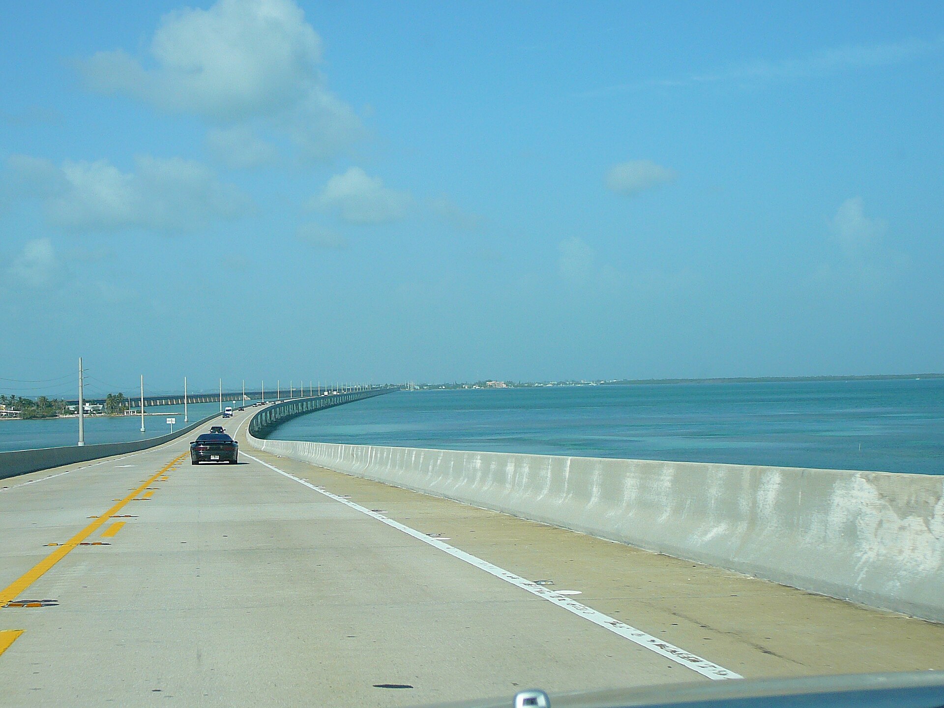
There is a specific moment, about two-thirds of the way across, where the road climbs to its high point at Moser Channel and the guardrail drops away on both sides, and for perhaps fifteen seconds there is nothing in any direction but water at three different depths. Everybody who has driven US 1 remembers it. The Seven Mile Bridge is not the longest bridge in Florida or even the longest in the Keys, but it is the one people mean when they talk about driving to Key West, and there are two of them running side by side — one you drive on, and one that was built for a railroad in 1909 and is far more interesting.
This guide covers what the bridge actually is, the history that got it built and then killed the railroad that built it, how to walk the restored section of the old span out to Pigeon Key, where to stop for photographs and which stops are worth the U-turn, and how to drive it without irritating everyone behind you. Prices and access were checked in September 2026; the old bridge in particular has been through a long rehabilitation, so confirm the current access before you plan a walk around it.
At a glance
| Fact | Detail |
|---|---|
| Location | MM 47 (Knight’s Key, Marathon) to MM 40 (Little Duck Key) |
| Actual length | About 6.8 miles — just short of seven |
| Current bridge opened | 1982 |
| Old bridge built | 1909–1912, as part of Flagler’s Key West Extension |
| Highest point | Roughly 65 feet, over Moser Channel |
| Walk the old bridge | Free; 2.2 miles restored from the Marathon end to Pigeon Key |
| Pigeon Key ferry and tour | Around $25–$30 adult |
| Best photo stops | Knight’s Key end, Sunset Grille parking, Little Duck Key beach |
| Time to drive it | About eight minutes at the 55 mph limit |
| Cycling | Legal on the highway shoulder; the old bridge is the pleasant option |
What it is, and what it is not
Two bridges cross the same water. The current one, opened in 1982, is a concrete box-girder structure carrying two lanes of US 1 with a narrow shoulder, rising over a hump at Moser Channel where the shipping channel needs 65 feet of clearance. The old one, a hundred yards to the north for most of its length, is Flagler’s railroad bridge — reinforced concrete arches and steel plate girders on concrete piers, converted for cars in the 1930s and retired when the new bridge opened.
Two small corrections to what people expect. First, it is not seven miles — it is about 6.8, and the name was a round number that stuck. Second, it is not the longest bridge in the Keys by clear span or by any modern measure of engineering ambition; the Long Key Viaduct is more beautiful and the current bridge is a workmanlike piece of 1980s highway concrete. What makes the Seven Mile Bridge famous is the experience of being on it and the ruin running alongside.
The history, which is the whole point
Flagler’s problem
When Henry Flagler decided in 1905 to push his Florida East Coast Railway from the mainland to Key West, the crossing between Knight’s Key and Little Duck Key was the hardest single stretch. Seven miles of open water, tidal current running hard through Moser Channel, hurricane exposure, no local labor, no fresh water and no materials. His engineers — chiefly William Krome and Joseph Meredith — solved it with a mixture of reinforced concrete arches on the shallow sections and steel plate girders on the deeper ones, all of it carried on concrete piers sunk to bedrock.
They also built a swing span at Moser Channel so shipping could pass, and they put a construction camp on Pigeon Key, a five-acre island under the bridge, which housed up to 400 workers. The concrete was mixed with fresh water brought down by barge and, later, by the railroad itself. Work ran from 1909 to 1912. Somewhere between several hundred and a thousand men died across the whole seven-year extension project, mostly in the three hurricanes that hit during construction — the 1906, 1909 and 1910 storms — and the toll on this section was among the worst.
The first train reached Key West in January 1912, with Flagler — 82 and nearly blind — helped down onto the platform to a crowd of thousands. He died the following year.

1935, and the end of the railroad
On 2 September 1935 the Labor Day hurricane came ashore over Islamorada as a Category 5 — still the most intense hurricane on record to strike the United States, with a central pressure of 892 millibars. The Seven Mile Bridge survived; the embankments and the roadbed further up the chain did not, and neither did the rescue train sent from Miami, which was swept off the tracks at Islamorada. Between 400 and 500 people died, many of them First World War veterans in New Deal road camps.
The Florida East Coast, already in receivership, never rebuilt. The state of Florida bought the right of way and the bridges for a reported $640,000 and set about converting them for cars.
The car years, 1938 to 1982
The conversion at Seven Mile was crude and the result was notorious. Engineers laid a narrow roadway across the railroad structure, giving two lanes with essentially no shoulder, a low railing and, at Moser Channel, a swing bridge that opened for boat traffic and stopped everything. Trucks met oncoming trucks with inches to spare. Drivers with a fear of heights got out and let somebody else take the wheel. When the swing span opened, cars sat in a line on a two-lane bridge in the middle of the ocean and people got out to stretch.
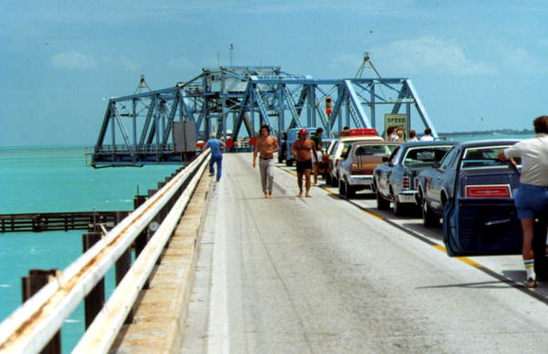
The current bridge opened in 1982 and the old one was closed to traffic. The swing span at Moser Channel was removed, which is why the old bridge now stops abruptly in the middle of the water — an 800-foot gap where the mechanism used to be.
Walking the old bridge to Pigeon Key
The 2.2-mile section from the Marathon end of the old bridge out to Pigeon Key has been rehabilitated for pedestrians and cyclists and is free to use. It is one of the best free things to do in the Florida Keys and it is also more demanding than people expect.
What it is like: a concrete deck about twenty feet wide, forty-odd feet above the water, with a railing and absolutely no shade. You look straight down into water clear enough to see rays, sharks, tarpon and turtles moving over the bottom. Cormorants and pelicans use the railings. Looking back you see the whole Marathon shoreline; looking forward, the modern bridge running parallel and the chain vanishing into haze.
Practical points:
- Go early. First light to about 9:00 a.m., or after 5:00 p.m. Midday on the deck in July is genuinely punishing.
- Take more water than you think. There is none on the bridge. The round trip to Pigeon Key and back is about 4.5 miles.
- Hat, sunglasses, sunscreen. The concrete reflects and there is nowhere to hide.
- Bicycles are ideal — the deck is smooth, flat and car-free, and a rented bike turns a hot walk into a pleasant half hour each way.
- Access hours and the far end change. The section beyond Pigeon Key is unrestored and closed. Check the current arrangements locally before you set out; the rehabilitation has been long and the details have shifted more than once.
Pigeon Key itself is worth the walk. Eight of the original railroad buildings survive on five acres — the section gang quarters, the bridge tender’s house, the assistant’s house — and the island is on the National Register of Historic Places. There is a small museum, shade, a swimming area and a dock. You can also reach it by ferry from near MM 47 for about $25–$30 including a guided tour, which is the right choice if walking two and a bit miles in the sun is not on the agenda. Our Marathon Florida Keys guide covers the ferry and the rest of the island’s attractions.
Photo stops, ranked honestly
You cannot stop on the bridge. There is no shoulder worth the name, stopping is illegal and unsafe, and the fatality statistics on the Overseas Highway are what they are. Every photograph gets taken from one of these places.
The Marathon end, Knight’s Key (MM 47)
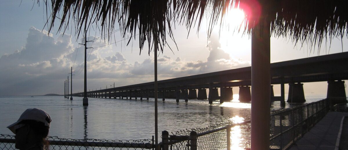
The best of them. Park at the old bridge access or the adjacent lot and you get both bridges receding into the distance in the same frame, with the old span’s arches in the foreground. Best in early morning with the sun behind you, or at sunset when the water goes gold. Walk out fifty yards onto the old bridge deck for the classic shot.
Little Duck Key and Veterans Memorial Park (MM 40)
The western end, and the underrated one. A small free beach with picnic tables, restrooms and shade, looking back east along the whole length of both bridges. Sunrise here is spectacular and almost nobody is present for it. It is also the best swimming spot at either end.
Sunset Grille and the Knight’s Key marinas (MM 47)
Restaurant parking with a view straight down the bridge line. If you are eating there anyway, take the photograph from the deck. If you are not, park considerately and be quick.
Pigeon Key, from the old bridge
The composition nobody expects: looking down at the railroad buildings and the dock with turquoise shallows all around. Worth the walk.
From the air
The most dramatic version of this bridge is aerial, and there are seaplane and helicopter operators who will show it to you. Our Key West photo spots guide covers the southern end’s shots and how to plan light there.
Driving it well
Eight minutes at 55 mph, and a handful of things that make it better for you and everyone behind you.
- Do not stop, and do not slow to 25 for a photograph. This is the single biggest source of irritation and of rear-end collisions on the bridge. Take the picture from Knight’s Key.
- Wind is a real factor. High-profile vehicles, roof boxes and towed trailers get pushed around on the hump in a stiff crosswind. Both hands, and slow down before you need to.
- Southbound in the morning and northbound in the afternoon means the sun is behind you. Northbound at 8:00 a.m. means driving into a low sun off wet concrete, which is unpleasant.
- Fuel up in Marathon. There is nothing between MM 47 and MM 30 except Big Pine.
- Cycling the highway is legal but not advisable — the shoulder is narrow and the traffic is fast. Cycle the old bridge instead.
- If the bridge closes — for an accident, for a marine incident, for a storm — nothing moves. There is no alternative route, in either direction, at all. That is worth remembering when planning a flight out of Key West.
The complete run down the chain, including timings, fuel stops and where the traffic actually backs up, is in our guide to driving to Key West.
Fishing, and the water underneath
The old bridge and the channel edges are productive shore fishing, and the bridge pilings act as artificial reef structure — the whole seven miles is essentially a linear habitat. Tarpon roll under the spans in spring, and snapper, jack, grouper and permit hold around the pilings year round. You need a Florida saltwater licence, available online, and you should check current signage for where fishing is permitted on the restored section.
Boaters pass under at Moser Channel, which carries the marked route between the Atlantic and the Gulf, and the current there runs hard on a spring tide. Snorkelers should stay well clear of the channel; the tidal flow is much stronger than the surface suggests.
The other bridges worth knowing about
Forty-two bridges carry US 1 down the chain, and a handful of the old railroad spans beside them are as interesting as this one. If the Seven Mile Bridge has caught your imagination, these are the follow-ups.
- Long Key Viaduct (MM 63–65) — 186 reinforced concrete arches, the image Flagler used on his own advertising, and by common consent the most beautiful thing his engineers built. The old span runs alongside the highway and part of it is a fishing pier.
- Bahia Honda Bridge (MM 37) — a steel camelback truss over a 35-foot channel, the highest span on the railroad. This is the one where the 1930s conversion put the roadway on top of the trusses because they were too narrow to drive through, producing a crossing that terrified two generations of drivers. A short section is walkable from inside Bahia Honda State Park.
- Channel Five and Channel Two bridges (MM 71–73) — the eastern end of Islamorada, both with pedestrian sections on the old spans and both excellent for tarpon in spring.
- Niles Channel and the Saddlebunch bridges (MM 10–26) — short, low and unremarkable to look at, but they cross the shallowest and clearest water in the chain. Slow down and look sideways.
- Jewfish Creek Bridge (MM 108) — the modern arch that replaced a drawbridge at the top of the chain in 2008, and the reason the entry to Key Largo no longer backs up for an hour on Friday afternoons.
Cultural footnotes
The bridge has been blown up on screen more than once. True Lies (1994) staged the most famous version, with a Harrier and a missile taking out a section of what is presented as the Seven Mile Bridge; the production used a decommissioned span and a great deal of model work. License to Kill, 2 Fast 2 Furious and Mission: Impossible III have all used the bridge or its lookalikes. The Seven Mile Bridge Run, held each April, is a race across the full length of the highway bridge with the road closed — a few thousand entrants, a lottery for places, and one of the very few chances anyone gets to stand still in the middle of it legally.
The honest verdict
As a destination, the Seven Mile Bridge is a fifteen-minute stop at Knight’s Key and a photograph, and that is a perfectly good use of it. What elevates it into something worth planning around is the old bridge: 2.2 miles of car-free concrete forty feet above clear water, free, leading to a preserved railroad camp on a five-acre island. Do that at seven in the morning on a bicycle and it is among the best hours in the Florida Keys.
What it is not is a scenic drive you should slow down for. Take the picture from land, drive the bridge at the speed limit with both hands on the wheel, and go back on foot when the sun is low. And do not plan a walk in the middle of a July afternoon; the deck has no shade at all, and people underestimate that every single day.
Frequently asked questions
How long is the Seven Mile Bridge really?
About 6.8 miles — 35,862 feet by the usual figure. The name is a round number that has stuck since the railroad era.
Can you walk on the Seven Mile Bridge?
Not on the highway bridge. A restored 2.2-mile section of the old bridge, from the Marathon end out to Pigeon Key, is open free to pedestrians and cyclists. The portion beyond Pigeon Key is unrestored and closed, and there is an 800-foot gap where the Moser Channel swing span was removed.
How do you get to Pigeon Key?
On foot or by bicycle along the restored old bridge from near MM 47, or by ferry from the same end for roughly $25–$30 including a guided tour of the railroad buildings.
When was the Seven Mile Bridge built?
The original railroad bridge was built between 1909 and 1912 for Flagler’s Key West Extension. It carried cars from 1938 until the current highway bridge opened in 1982.
Where is the best place to photograph the Seven Mile Bridge?
The Knight’s Key end at MM 47, where you can get both spans in one frame from the old bridge deck, and Veterans Memorial Park on Little Duck Key at MM 40 for sunrise looking back east. You cannot stop on the highway bridge itself.
Is it scary to drive across?
Far less than it was. The 1982 bridge has proper lanes, a solid barrier and a gentle grade. If you were told a horror story about the crossing, it was almost certainly about the old bridge, which had two narrow lanes, no shoulder and a low railing.
Is there a toll on the Seven Mile Bridge?
No. US 1 through the Keys is toll-free for its whole length. The only toll in the region is on Card Sound Road, the alternative entry to Key Largo from the mainland.
If the bridge from above is what you are after and you would rather not wait for a seaplane schedule, the operators at the southern end will fly you over the whole chain. Our Key West helicopter tour guide covers what those flights cost, how long they last and which seat to ask for — the bridges and the shallow banks are the best part of the route.
Related Key West Guides
- The Florida Keys beyond Key West — the whole chain, island by island
- Marathon Florida Keys — the island at the bridge’s eastern end
- Big Pine Key and the Lower Keys — what lies west of the bridge
- Driving to Key West — the full route, timings and stops
- Key West photo spots — where and when to shoot at the southern end
- Bahia Honda State Park — the next island west, and its own old rail bridge
Photo Credits
Sunset over both Seven Mile Bridges from the Marathon end: 7 Mile Bridge by Franz Stellbrink, CC BY 3.0, via Wikimedia Commons.
Driving over the Moser Channel hump: Moser Channel top by Marc Averette, CC BY 3.0, via Wikimedia Commons.
Traffic waiting at the open Moser Channel swing span: Traffic waiting for Moser Channel turnstile bridge by Dale McDonald, Public domain, via Wikimedia Commons.
Sources & corrections
Rates, hours and closures verified against operator listings and on-island visits. Prices are peak-season unless noted.